Current Field Work Opportunities
The Central Chapter has Field Work Opportunities throughout the area during the summer months. We will post any opportunities here.
Past Field Work
|
Pine Valley Park Archaeological Site Investigation
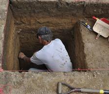
Central Maryland Chapter led an ongoing archaeological investigation at Pine Valley Park Native American hunter-gatherers rhyolite transport stopover, tool processing and food procurement site in Manchester, Carroll County, Maryland. The investigation was sponsored by the Central Maryland Chapter and the Board of Directors for the Manchester Parks Foundation. The first field season was in 2007 when a small hunter-gatherer site was discovered in the Maryland Piedmont. Test excavations have continued through the summer of 2013. The small plow zone site is located in elevated and prolific rolling hills with dependable fast flowing headwater springs and a wetland stream terrace habitat. The site setting is within a small protected basin that drains into the major rivers Susquehanna, Potomac, Monocacy, Patapsco and the Chesapeake Bay. The stone tools are comprised of narrow blade stem points, small side and corner-notched points, broad blade knives, light flake waste debitage, shallow roasting basin pits, one with an unmodified Beta Analytic AMS radiocarbon dates ranging from of 3900 ±40 years BP to 2120±30 BP. |
Overview of the Smithson/Island Branch Floodplain Archaeological Site Investigation on Deer Creek
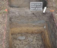
Central Maryland Chapter in collaboration with the Northern Chesapeake Archeology Society conducted an archaeological reconnaissance in June, July and September, 2013 to re-evaluate the Smithson Floodplain Tract on Deer Creek for its archaeological potential and significance in the upper reaches of the Deer Creek, immediately downstream of Madonna Road in Harford County, Maryland. The investigation was undertaken to obtain additional information on Wes Herrmann’s Native American stone tool surface finds from (1998 to 2005) on the 6 acre narrow floodplain parcel. Wes Herrmann also identified a concentration of 19th century ceramic, glass and iron artifacts in the southwest corner of the field and along the edge of the former wagon road, now Telegraph Road along a terrace. The auger probes in June and the initial three hand-dug test trenches in July, 2013, on the terrace recorded a series of six to ten soil lenses associated with high velocity stream flows and past flooding events above stream cobbles. Scattered historical artifacts were recovered from the first soil lenses. In September, a fourth test trench was placed at the foot of ridge slope and edge of the floodplain. A buried A-Horizon soil lens was found two feet deep in a thin dark lens(Lens 5). Lens 5 contained quartz cobbles reduction flakes, a prepared large quartz cobble core, quartz cobble shatter or FCR, and a single glossy white quartz cobble fragment. |
